
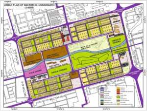
Urban Map of Sector 36, Chandigarh
Preparation of Urban Map of Sector 36, Chandigarh as a part of my coursework
Preparation of Urban Map of Sector 36, Chandigarh as a part of my coursework

CV format is the way you present your work experience, education, skills, and accomplishments. It’s a great way to sell yourself in an interview.
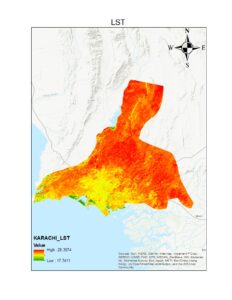
I used Arc GIS to create this map showing surface temperature distribution of land. I choose karachi a city of pakistan to perform this task
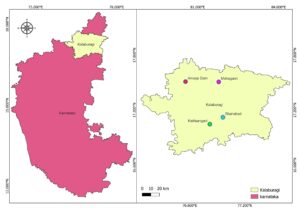
This map is represent the West Bengal transport and capital city map with coordinate. One of the best state in India.
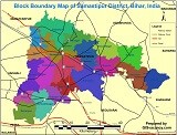
Block Boundary, Rail, Road, sub-division Map of Samastipur District of Bihar State, India. Samastipur map 🗺 like Road, Rail, block list, sub-division, Village, Tehsil maps.
Preparation of Urban Map of Sector 36, Chandigarh as a part of my coursework
CV format is the way you present your work experience, education, skills, and accomplishments. It’s a great way to sell yourself in an interview.
I used Arc GIS to create this map showing surface temperature distribution of land. I choose karachi a city of pakistan to perform this task
This map is represent the West Bengal transport and capital city map with coordinate. One of the best state in India.
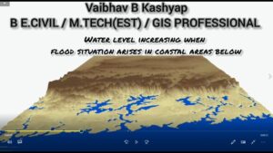
1. Introduction: WATER LEVEL ANIMATION TO DISPLAY FLOOD SITUATION IN COASTAL AREAS, MAHARASHTRA INDIA BY ARCGIS 20222. Objective: To design the waterflood level by defining
Preparation of Urban Map of Sector 36, Chandigarh as a part of my coursework
CV format is the way you present your work experience, education, skills, and accomplishments. It’s a great way to sell yourself in an interview.
I used Arc GIS to create this map showing surface temperature distribution of land. I choose karachi a city of pakistan to perform this task
This map is represent the West Bengal transport and capital city map with coordinate. One of the best state in India.
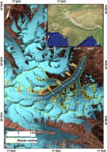
Area of Interest: Remote Sensing and GIS Keyword: Surge, Karakoram, Mass transfer, Surface displacement, DEM differencing Summary (surge dynamics) The Karakoram region contains a large
We have detected that you are using extensions to block ads. Please support us by disabling these ads blocker.
